~ Tarajories ~
Hill of Health ~
~ Maps
~
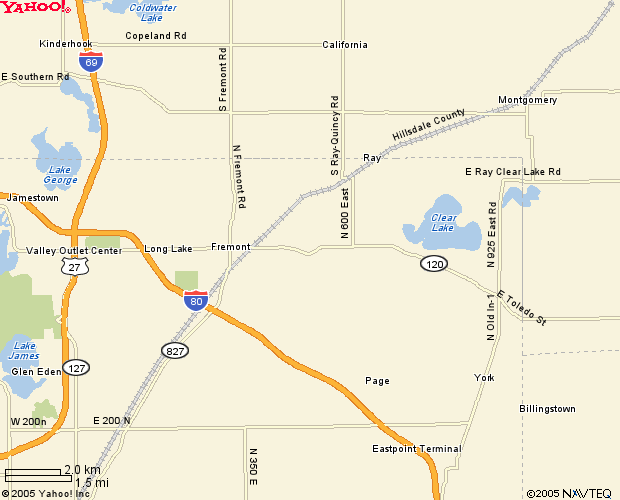
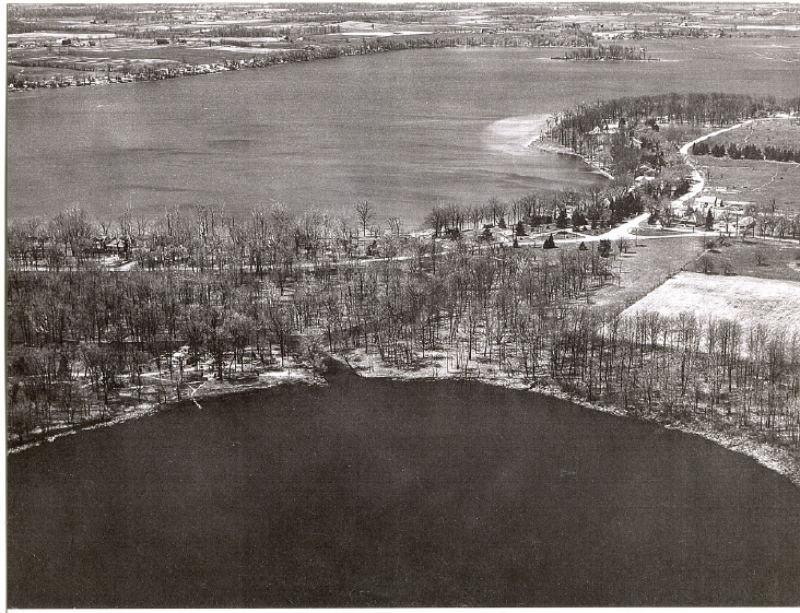
The following finds a Yahoo map of the area and 2 scanned photos circa 1920s, we're told, from the T. P. Riddle, Sr. archives. Click on the Yahoo map below to get to the Yahoo online maps for review of adjacent arenas. Lake Anne is closely connected to the east bay of Clear Lake, obscured by the N 925 East Rd. notation on this map. Shown clearly on the next 2 scans from the 1920s, find desolate winter photos of the terrain at the time showing land already having been cleared by settlers after the original incumbents were vacated. However, one can clearly see Lake Anne and our now plush, floral-lined lily-filled lagoon connecting in very close proximity to Clear Lake where one can easily avail oneself of Clear Lake by boat should one care to do so. The entire surrounding terrain and cleared fields in these 2 photos have since overgrown with lush, towering forestry of both hardwoods and pines, brimming with the area's natural flora and fauna. Click both scans for current photos featuring our Crown Jewel in the Emerald Necklace of this ultra-high-end resort setting offering over 4 and 1/3 prime private acres of plush, forested lake and lagoon real estate in Spring, Summer, and Fall, yours for the bidding.
Orienting with primordial Lake Anne in the foreground, the main manor now on our property, not yet built in this photo, rests centered between the entrance of the lagoon and our property line to the north. Clearly designated by the line following the south side of the snow-dusted empty square patch of farm field at our north property line which is now a densely forested variety of pines towering 40 - 60 feet tall, our property line runs from the waters of Lake Anne all the way out to the street, Lake Drive. Notice the obvious depths of our 'kettle hole' Lake Anne in her crystal-fresh 5-spring-fed waters also appearing larger than Clear Lake in this photo. Notice the expanse of plushly forested private property in comparison to other cottage-lined lakes in lieu.
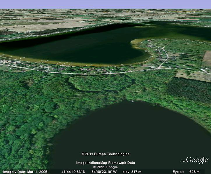
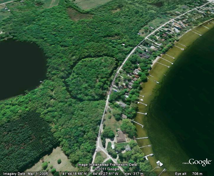
2011 plush greenery regrown from days of yore, long before the devastation of man shown in the photo above, this Google Earth map provided compliments of Doug Cottrell, Winnipeg, Manitoba, Canada, thank you very much. As you can see, the last of the thick, plush greenery lies here with us, the Camelot and Crown Jewel in the last of what's left of the ever dwindling Emerald Necklace of Clear Lake, complete with private moat, Lake Anne and Lagoon which we protect with our lives. Thanks to Mr. Merrill, what was shown as the bright, barren, snowy patch to the right above is now thick with Pine; Red, White, and Jack among ancient Oaks and other towering deciduous faire of the forest. Google Map's deep forest green patch clearly defines our property line running along-side the entire expanse from Lake Anne to Lake Drive. The south property line runs along the lagoon about a third or more of the way around, then cuts in about 25 feet along the lagoon behind the Gentlemen's Quarters and out to the street just the other [south] side of the 2 small pines at the street or even a bit further down, clearly shown in the original photo below. Distance view at top of this 2011 greenery photo clearly shows the misfortune of only scant greenery left in outlying areas. Contrast our densely protected 4.334 acres with private, spacious single-family dwellings and 461 spacious, wraparound, waterfront footage to the 40, 60, and 80' line-up across the street. Lagoon access provides immediate access to Clear Lake proper... which would you choose, as the man says?
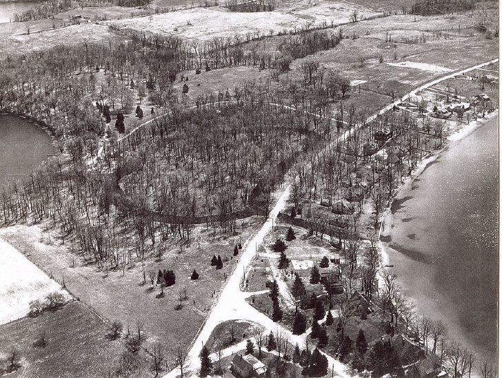
Rather disorienting, the clearing at the top of the Ceremonial Hill above the south shores of Lake Anne can be found in the top left quarter of the scan below, rather sort of it seems. Chief Red Jacket's burial rock now nests at the crown having been moved from its original burial location on the north shores of Clear Lake, with the area now also overgrown with thick, plush, green forestry shown in the new 2011 Google Maps of 'doesn't get any greener than this.' Both Mr. and Mrs. T. P. Riddle, Sr. are also buried in this 'Reserve' under Chief Red Jacket's burial stone. The scan below also clearly shows our property line at the street where our midst is just about where the incoming T makes the tri-corner easily seen on these dusty-white roads. A nasty bite was covertly taken from us along with a larger parcel or 2 elsewhere, not included with this purchase, both larger parcels still under contention, with the strip mentioned herein running just along the banks of the lagoon from our west property line at the back of our property about half way down the lagoon paralleling the lagoon banks out to the street. Being boggy, this strip will never be disturbed, nor will the island. We include these two 1920s black and white brilly winter scans to offer a clear picture of the terrain without obscuring the property with summer foliage. Click both black and white scans to warm up with summer color photos. 2011 greenery map with relative property lines is forthcoming below.
And many thanks again to the Master of Graphyx, Doug Cottrell, for this Then and Now Collage.
.jpg)
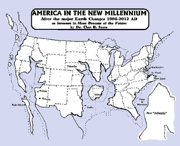
For anyone looking for a safe zone for the possible upcoming earth changes, natural or manmade as the story goes, notice our very safe arena on the Edgar Cayce map below. The Edgar Cayce maps are said to be those used by the US military for readiness efforts. Other camps additionally report one of the new spiritual Golden Cities being just a bit to the south of us on this map. Whether this will actually occur, we know not, but the fact remains. Safe here now, and thereafter, with additional self-sustaining support immediately on the property.
And to warm up this page a bit, find the next two fall color photos of our split rail fenced and gated entrance at Lake Drive as noted above where the T ends at the tri-corner in the black and white scan above. Shown below streetside in beautiful, warm, sunny fall color photos find evidence of profusely overgrown forestry of protection, privacy, and seclusion with the cleanest air, water and soil anywhere these days.
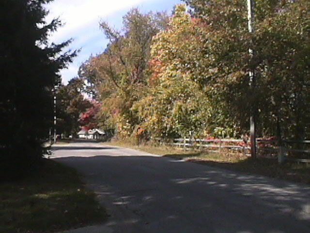
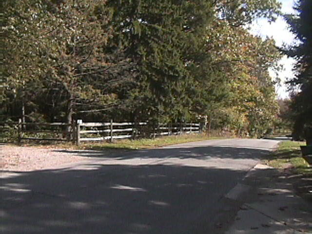
A north view of Lake Drive above taken from our private, gated entrance clicks to a slide show of seasonal lagoon wonder, split rail fence long rounding the bend, obscured, in expanse extending to the northernmost property stake. South view below shows the weathered split rail fence extending to the southernmost property line, not quite to the Lagoon, jpg clicks to a series of seasons highlighting the main manor. Our protected arena thrives even when surrounding outlying areas suffer extreme drought or other extreme weather conditions. This, again, is more evidence to prove the null zone and micro-climate we as blessed to enjoy, and further evidence of lessons learned.
Zillow! for the Concise Version ~ current price $1,997.000 good until May 31, 2011
Links to Affiliate Website Listings ~ See Us On Yahoo!
Stories
Back to Text Explanations Page
Photo Tours Revisited
Table of Contents
Casual private bidding suggested @ $2,599,000... for those who know... original list price now reduced to $1,997,000 USD good until May 31, 2011. Due to the uncertain nature of the 12-21-2012 prophecies and continued devastation around the globe in evidence, we will be incrementally increasing the price to our initial list as we are self-sustainable here and time is growing too short to get set up elsewhere as survivable as we are here. Drive-thrus welcome. Preferably shown with advance notice, but not required. 3% commission if your contact buys so spread the word!
Contact: Evan @ 1-260-495-3211, Indiana USA, Eastern Standard Time
 See our Lakehouse ad for a concise version, quick stats & comps